Today is: |
F A Q |
Why is it important to verify the location of the property you intend to buy |
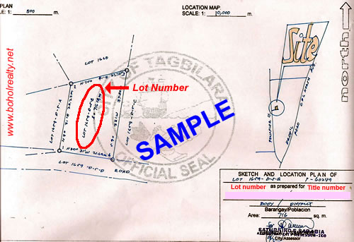
Few years ago a client requested his property to be listed for sale, however upon the review of the documents it was discovered that the location was not as he described. The owner recalled that when he bought the property it was through the recommendation of a friend and since he was outside the country when the transaction took place he relied mainly on the description mentioned by the seller. Though it was situated in the same vicinity the specific lot does not have a legal right of way only an access path which can be closed at anytime if the adjacent lot owner decides to do so. In general the property has lost significant value given the condition. One way to verify is to secure a SKETCH and LOCATION PLAN (sample shown below) which can be obtained from the assessor's office of the city or municipality where the property is located or from the geodetic engineer who was responsilbe for the survey of the particular lot.The information is extracted from the TAX MAP (if secured from the assessor) where it is updated everyttime there are changes in the status of the lot like for example in the event of a sale or if a single lot is being subdivided into smaller parcels. The information like the lot number, title number, lot area, number of corners or monuments can be cross referenced with the title. It is important to secure these document for location verification prior to entering any form of contract involving a real estate property in order to confirm the information as disclosed by the seller. |
 |
Other related articles: |
| I |
| Bohol Realty contact info: |
| Cell: +63 0929-274-1111 (SMS) |
| Tel: US +1 (626) 248-7304 |
| E-mail: boholrealty@gmail.com |
FEATURED PROPERTY |
www.boholrealty.net copyright 2007-2016, All rights reserved |
Follow us: |


